Skip to header Skip to main navigation Skip to main content Skip to footer

User account menu

  • Log in
Home
American Falls Dam

Main navigation

  • Home
  • Dining
  • Lodging
  • Shopping
  • Things to Do
  • Outdoors
  • History
  • Webcams
  • Business Directory

Article Archive

Carey Act Water and the Making of Power County Farms
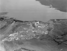
A 1923 aerial photograph of Minidoka Dam and Reservoir near Rupert, Idaho, by Captain A. W. Stevens.

Power County's farms were made by law as much as by labor. In the last part of the nineteenth century, privately financed irrigation canals first began to sustain the emerging agriculture industry in southern Idaho, and by 1895 an American Falls irrigation project was already before the Idaho State Land Board. Two statutes turned that local ambition into a regional transformation: the Carey Act of 1894 and the National Reclamation Act of 1902, signed by President Theodore Roosevelt on June 17, 1902.
  • Read more about Carey Act Water and the Making of Power County Farms

The Buildings That Moved: Churches, Homes, and the Oneida Grain Elevator

The relocation of American Falls is usually told in totals, but it happened one building at a time. Between January 1925 and July 1926, movers hauled 344 residences, forty-six businesses, three hotels, one school, six churches, one hospital, six grain elevators, and one flour mill from the old townsite by the river up the hill to the new Reclamation Addition. The buildings traveled on wheeled carts and rollers, by horse and by truck, over a temporary moving road that crossed the dam construction area and followed the old Oregon Trail up the hill.

  • Read more about The Buildings That Moved: Churches, Homes, and the Oneida Grain Elevator

Massacre Rocks State Park Today

Ten miles southwest of American Falls, where Interstate 86 crosses the Snake River, Massacre Rocks State Park preserves the most famous passage on Idaho's stretch of the Oregon Trail and pairs it with a full menu of modern recreation. The park covers about 990 acres of basalt boulders, sagebrush, and riverbank in Power County, at 3592 North Park Lane, reached from Interstate 86 at Exit 28. Idaho State Parks lists day-use hours of 7 a.m. to 10 p.m., the National Park Service notes that a modest admission is charged, and the park is open year-round.

  • Read more about Massacre Rocks State Park Today

Fishing American Falls Reservoir: Perch, Trout, and Bass

American Falls Reservoir is one of Idaho's great working fisheries, an irrigation reservoir of more than 55,000 acres in Bannock, Bingham, and Power Counties that Idaho Fish and Game lists as a recommended fishing water. The Department lists its facilities plainly: a boat ramp, a dock, a toilet, and a campground, with handicap-accessible facilities and no motor restriction. What draws anglers is the variety. Fish and Game's recommended game fish for the reservoir are rainbow trout, brown trout, cutthroat trout, smallmouth bass, largemouth bass, and yellow perch.

  • Read more about Fishing American Falls Reservoir: Perch, Trout, and Bass

The Reservoir That Changed the Land

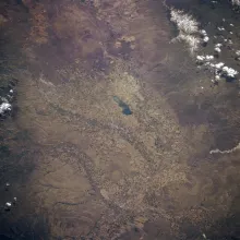
American Falls Reservoir and Pocatello, Idaho, photographed from the Space Shuttle in May 1985.

When the gates of the first American Falls Dam closed, the Snake River backed up for more than twenty miles and became the largest reservoir of the Minidoka Project. American Falls Reservoir stores about 1.7 million acre-feet of water, and at full pool it covers some 56,000 acres with about 100 miles of shoreline. The dam stands in Power County, but the reservoir reaches northeast into Bingham and Bannock Counties, and it remade everything it touched.

  • Read more about The Reservoir That Changed the Land

A New Dam for a New Era: The 1978 Replacement Dam

The first American Falls Dam served for half a century, but by the 1960s it was failing from the inside. A core-drilling program in the early 1960s revealed that the concrete in portions of the original dam was in a relatively advanced stage of deterioration, caused by a chemical reaction between the alkalis in the cement and the aggregate. The reaction caused a significant loss of strength and durability, and officials imposed a fill restriction that reduced the reservoir's storage to about sixty-six percent of its maximum design capacity.

  • Read more about A New Dam for a New Era: The 1978 Replacement Dam

Power at the Falls: The 1902 Plant and Idaho Power's Early Years

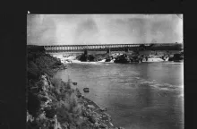
The natural falls at American Falls and the railroad bridge, photographed for the Historic American Engineering Record, HAER ID-2.

Power County is named for a power plant. When the Idaho Legislature created the county on January 30, 1913, with American Falls as its seat, it took its name from the hydroelectric plant at the falls, where the Snake River poured over a series of basalt cascades. The Idaho State Historical Society's county-names reference gives the origin in a single line: "Power: For the power plant at American Falls."

  • Read more about Power at the Falls: The 1902 Plant and Idaho Power's Early Years

Fort Hall and the Shoshone-Bannock Homeland

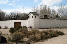
The Fort Hall Replica Museum in Pocatello, Idaho, photographed by National Park Service staff.

Long before there was a town at American Falls, this country was the homeland of the Shoshone and Bannock peoples. The Shoshone-Bannock Tribes are comprised of the eastern and western bands of the Northern Shoshone and the Bannock, or Northern Paiute, bands. Their ancestral lands encompassed present-day Idaho, Oregon, Nevada, Utah, Wyoming, and Montana, and reached into Canada.

  • Read more about Fort Hall and the Shoshone-Bannock Homeland

Register Rock: The Emigrants' Guest Book in Stone

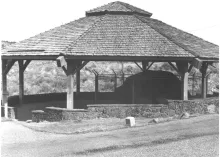
Register Rock sheltered beneath its octagonal pavilion, photographed by Merle W. Wells for the National Register of Historic Places nomination.

Every guest book has a first signature. At Register Rock, the signatures were cut into stone. The rock is a partially buried basalt boulder about twenty-five feet in diameter and nearly seven feet high, standing near Rock Creek and the Snake River, about twelve miles southwest of American Falls. Emigrants on the Oregon and California Trails camped in this spot, rested their animals, and many of them took a few moments to leave their names on the boulder before rolling on west.

  • Read more about Register Rock: The Emigrants' Guest Book in Stone

Massacre Rocks: Where the Oregon Trail Ran a Gauntlet

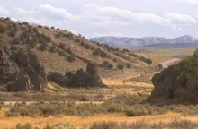
Devil's Gate at Massacre Rocks, the narrow gap in the boulders where Oregon Trail wagons passed in single file.

West of American Falls, the Oregon Trail crossed one of the most storied passages on the whole route west. During the emigrant era of 1840 to 1860, thousands of travelers who had left Fort Hall and crossed the Snake River Plain, more than 1,200 miles out of Missouri, reached a place where the trail narrowed to a gap between enormous basalt boulders on the south bank of the Snake River. Wagons had to pass through in single file. Emigrants called the gap Devil's Gate, and some called it the Gate of Death.

  • Read more about Massacre Rocks: Where the Oregon Trail Ran a Gauntlet

Pagination

  • Current page 1
  • Page 2
  • Next page ››
  • Last page Last »

American Falls, ID Weather

Loading current conditions...

Loading forecast...

Upcoming Events

🎉 American Falls Events Calendar

Annual Favorites:
American Falls Day — First Saturday of August
Power County Fair and Rodeo — August

Coming Up:
Watch the chamber calendar for winter and holiday events in American Falls.

Article Archive

Browse past articles

Copyright © 2026 Rocky Mountain Madman LLC - All rights reserved

Developed and Designed by Rocky Mountain Madman LLC